

WARNINGS AND HAZARDS

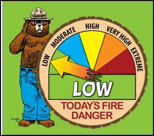
TODAY’S FIRE LEVEL
TODAY’S WEATHER WARNINGS
San Bernardino County Mountains-Apple and Lucerne Valleys- Including the cities of Crestline, Lake Arrowhead, Big Bear City,
Big Bear Lake, Running Springs, Wrightwood, Victorville, Hesperia, Apple Valley, and Lucerne Valley Thu Apr 25 2024
…WIND ADVISORY REMAINS IN EFFECT UNTIL 11 PM PDT FRIDAY…
* WHAT…West winds 30 to 40 mph with gusts to 60 mph.
* WHERE…San Bernardino County Mountains and Apple and Lucerne Valleys.
* WHEN…Until 11 PM PDT Friday.
* IMPACTS…Gusty winds could blow around unsecured objects. Tree limbs could be blown down.
* ADDITIONAL DETAILS…Winds each day will be strongest in theafternoon and evening.
PRECAUTIONARY/PREPAREDNESS ACTIONS…
Use extra caution when driving, especially if operating a high profile vehicle. Secure outdoor objects.
&&
FIRE WEATHER OUTLOOK


FIRE WEATHER FORECAST
DISCUSSION…
Continued cooler through Friday night with stronger and gusty southwest to west winds for the mountains and deserts and a deep
marine layer with drizzle or light rain from the coast to mountains, mainly during nights and mornings. Warmer and drier for
the weekend through early next week with high temperatures early next week around 5 degrees above average. Winds will be lighter and the marine layer will become shallower. There is greater model spread on just how much cooling and deepening of the marine layer may occur the latter half of next week from a low pressure system moving inland along the West Coast.
Fire Weather Forecast San Bernardino County Mountains-
.TODAY…
Sky/weather Cloudy…becoming partly cloudy. Patchy fog in the morning. Slight chance of showers in the morning.
Max temperature…..48 to 58 above 6000 feet to 52 to 62 below 6000 feet. 24 HR TREND……Down 1 degree.
Min humidity……..25 to 35 percent on desert slopes to 50 to 60 percent on coastal slopes. 24 HR TREND……Up 40 percent.
WIND (20 FT)……..SLOPES………..Winds west 19 to 29 mph with gusts to 45 mph.
RIDGETOP………Winds west 19 to 29 mph. Gusts to 55 mph…becoming 40 mph in the afternoon.
.TONIGHT…Sky/weather………Partly cloudy…becoming mostly cloudy. Patchy fog after midnight.
Min temperature…..27 to 37 above 6000 feet to 35 to 44 below 6000 feet. 24 HR TREND……Up 1 degree.
Max humidity……..50 to 60 percent on desert slopes to 90 to 100 percent on coastal slopes. 24 HR TREND……Little change.
WIND (20 FT)……..SLOPES………..Winds west 19 to 29 mph with gusts to 40 mph.
RIDGETOP………Winds west 22 to 32 mph with gusts to 50 mph.
.FRIDAY…Mostly cloudy…becoming partly cloudy. Patchy fog in the morning. Slight chance of showers in the morning.
Max temperature…..46 to 56 above 6000 feet to 51 to 61 below 6000 feet. 24 HR TREND……Little change.
Min humidity……..30 to 40 percent on desert slopes to 55 to 65 percent on coastal slopes. 24 HR TREND……Down 5 percent.
WIND (20 FT)…….. SLOPES………..Winds west 21 to 31 mph. Gusts to 45 mph…becoming 55 mph in the afternoon.
RIDGETOP………Winds west 24 to 34 mph with gusts to 60 mph.
FORECAST DAYS 3 THROUGH 7…SUSTAINED WINDS LESS THAN 20 MPH EXCEPT WHEN SPECIFIED
.FRIDAY NIGHT…Partly cloudy. Slight chance of showers in the evening. Patchy fog after midnight. Lows in the upper 30s. West
winds around 15 mph.
.SATURDAY…Mostly sunny. Highs in the upper 50s. West winds around 9 mph.
.SATURDAY NIGHT…Mostly clear. Lows in the lower 40s. West winds around 7 mph.
.SUNDAY…Mostly sunny. Highs in the mid 60s. West winds around 6 mph.
.SUNDAY NIGHT…Clear. Lows in the mid 40s. West winds around 6 mph.
.MONDAY…Sunny. Highs in the upper 60s. South winds around 6 mph.
.MONDAY NIGHT…Mostly clear. Lows in the upper 40s.
.TUESDAY…Mostly sunny. Highs in the lower 70s..TUESDAY NIGHT…Mostly clear. Lows in the upper 40s.
.WEDNESDAY…Mostly sunny. Highs in the upper 60s.


THUNDERSTORM OUTLOOK